In the first week of June 2024, we drove up the Mustang to perform religious rituals at Kagbeni, the confluence of Mustang Khola and Kagkhola which then become the Kali Gandaki River. What used to be a trekking route to Mustang has now been overtaken by a motorable road that is being upgraded rapidly.
The best part about the drive northwards along the Kali Gandaki River is to witness tell-tale signs in the hillsides, the cliffs, the rivers of the birthing process of the Himalaya and the layers of lesser mountains to the south. Of course a lot of those evidence at eye level have been carved away while widening the roads. But it is still awe-inspiring to travel alongside a river that has been carving its way down the ever rising mountains following the collision of the Indo-Australian and Eurasian tectonic plates about 40 million years ago.
At Dana of Myagdi district the Kali Gandaki squeezes through a very narrow channel called अन्ध गल्छी (Andh Galchhi). The river writhes its way down a narrow curvaceous gorge, said to be the deepest gorge in the world flanked by the 8K Himalayan peaks
of Dhaulagiri (8167m) and Annapurna 1 (8091m). As the crow flies, these two peaks are just 35 km apart, and the gorge is about 5000m below them.
There is a suspension bridge these days over the narrowest portion of the gorge, giving a spectacular experience of
sight and sound, as well as the awe about the origins of the land around. As you see the roaring waters below, you cannot but think about the landmasses that collided, went under, crumpled up, drained the Tethys Sea, and rose up in folds, lifting up the marine sediment in the process ( a reason one finds fossils in the Kali Gandaki river bed in Mustang).
Exact location of the gorge as per Google map👇
Exact location of the gorge as per Google map👇

https://maps.app.goo.gl/v6aYJZ3namwiWZoD9
When you arrive at the spot it is hard to make out where the river is! What guides you is its relentless roar

Once you step on the bridge, though, the river appears. Looking northwards one also notices the steep cliff through which the road is being carved. (Wish they would not dump the excavated rocks down the gorge, as reported by the locals)...

In this clip, looking northwards, you get a sense of the depth of the gorge, knowing there are steeper slopes beyond...
The clip below is looking southwards from the bridge, and the road that has been cut with difficulty into the cliff
How many years has it taken for the Kali Gandaki to carve it's way down here? The land is said to be pushing and rising 5 cm a year

The mighty Kali Gandaki as seen from the suspension bridge
Looking northwards into the high Himalayan foothills

The river chugs along carving huge boulders in the way...

... as well as the sides of the gorge...

.. it spills over rocks...

.. Right below the bridge the river almost disappears... this is the northern side of the bridge...

... and this is the southern side...
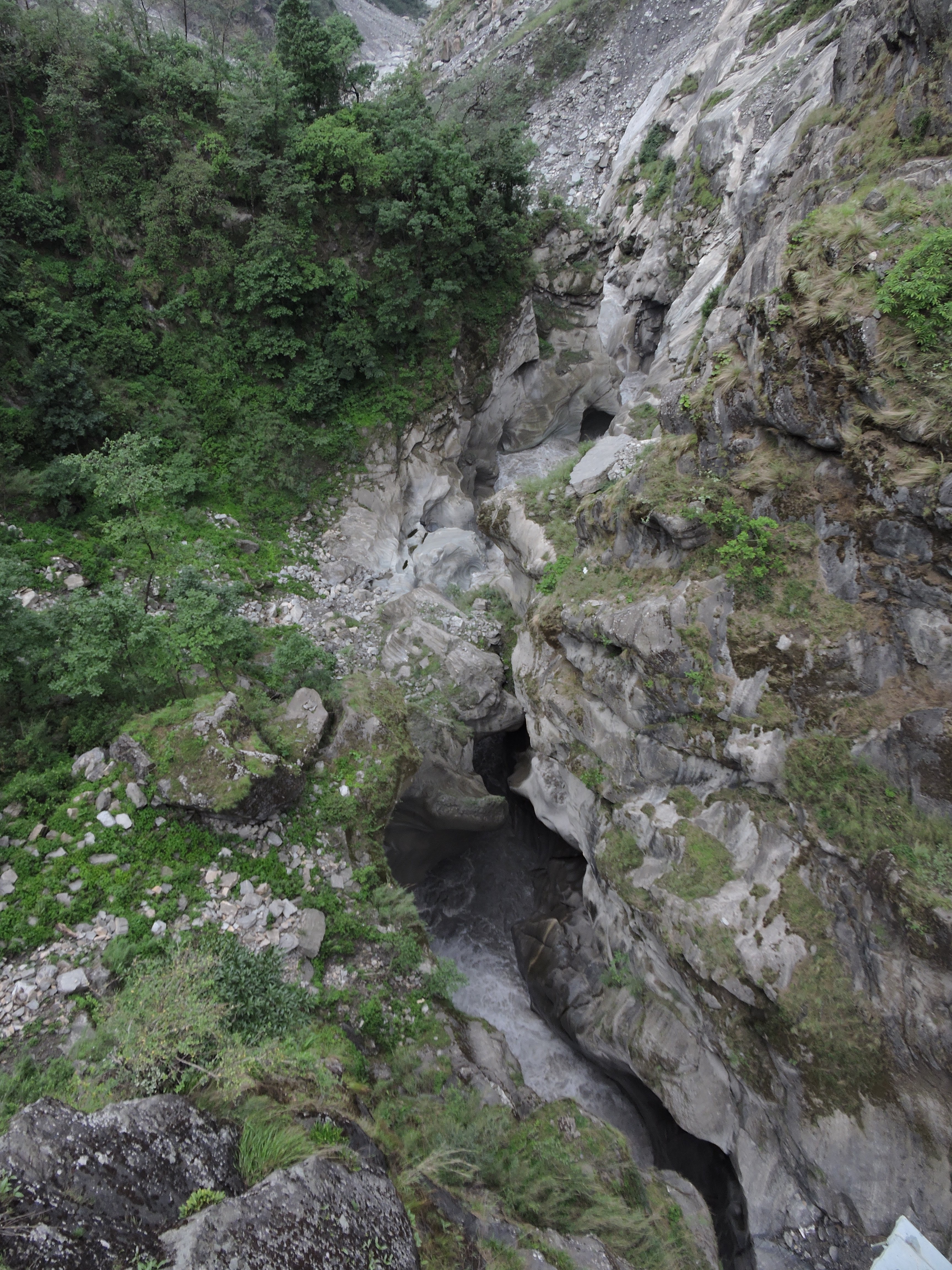
this is the point where the river drops down over a rapid.. and what gives the roaring sound magnified even more by hollow caverns...

Rocky cliffs have been chiseled by the river into wavy patterns...


... looking even closer at the rocks...


... nature's beautiful artwork...

... And finally.. looking southwards.. and the river frees itself from the constricting gorge.. and winds it way across the mountains and valleys. It will be meeting and greeting other smaller rivers before merging with Trisuli at Devighat to become Narayani and then to be known as Gandak across the border in India.

Leaving the Andh Galchhi behind we then headed northwards to Mustang... along a cliff that had been carved by Kali Gandaki before and now further cut away by humans!
more from the trip in my next blog...
# # # #
Rupa, thank you for your detailed post. Enjoyed reading it
ReplyDelete