this is the first in the series of images from our trip to myanmar.. our, meaning first baba and me, then dada, shanta and eelum, and then sandaji, all descending on various dates to the former burma. i will be posting images from our trips to various places--yangon, kyaikthiyo (pronounced chaithiyo), bagan, mandalay and the new capital nay pyi taw, in other postings...
but first, the view from the skies starting from, and ending in, kathmandu... i'm a 'have-to-see-what's-below' person.. unfortunately didn't get the best seats for the purpose all the time, or even if i did, the window surface were terrible!!
taking off from kathmandu and piercing the winter haze. the new highway to bhaktapur in the centre and the sukumbasi basti by the banks of the manohara on the left

the lazy sprawl of the 'dragon' nagarjun, with the city clawing at its foothills... ganesh himal, himalchuli and even annapurna in the backdrop

looking over sankhu on the right, and dwarfed shivapuri, and langtang and the jugal himals at the back

hills,himals and beyond...

the banepali channel

malpi and panuati...

sagarmatha's neighbours...

and the dusky lady with the plume herself.. standing tall

myanmar and thailand seem have mountains that mainly run north to south... but fascinating to see these peaks rising out of the bay of bengal off the myanmar coast, just south of where bangladesh ends...


while we were flying over myanmar the sun was setting on the other side of the plane. below us the sunrays were being reflected on golden pagodas. the ruddy rays of the sun could also be seen over the aircraft wings. in this image the shadow of the the tail just creeping on to the wings too...

puffs of clouds also reflecting the sunsety rays

as the sun goes lower, so grows the shadow of the fuselage and tail...

... until it swallows it completely!

this is the scene from the next morning as we fly in to yangon (formerly known as rangoon. those same ridges running north to south jutting out like a something-saurus' back

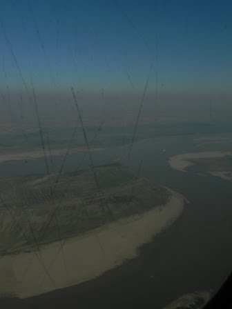
descending towards yangon airport, this is the river delta of the ayeyarwady (airawati or irrawaddy)river, and also part of the path taken by the deadly cyclone nargis in 2008

very strange land holding patterns.. fields pockmarked with groves of trees

we bank left to line up for the airport

we wait for 10 minutes once we cleared off the runway, waiting for a push/pull towing vehicle to drag the aircraft to the gate.

domestic portion of the airport

here is the same domestic section, a few days later, while we were flying out of yangon to go to bagan (pagan)

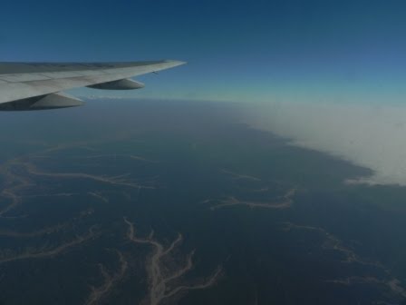
a 'dead' volcano rises above the haze as we head north

mountains that really look like crocodiles!

this as we are flying out of bagan to mandalay. the shadow will tell you that it is an atr. we had a nepali steward on the flight, a sudeep subedi from mogok! but look at the scratches on the window!

bagan by the airawati

river islands on the airavati, where people rush in to plant peanuts and other vegetables as soon as the waters recede.

the rare bridge over the river.. this one under construction

and as we descend towards mandalay international airport, we flew over the newly commissioned highway that connects mandalay to yangon through the nay pyi taw.. but this new airport is a good hours' drive away from the city!

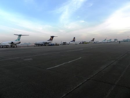
time to leave myanmar a fortnight later. this picture of the sanction-hit air bagan airbuses waiting by the side at yangon airport

this image over thai airspace as we head towards kathmandu.. was fascinated by the long rectangular fields for part of the way, which then gave way to more hotch potch land holdings...

we do aerial darshan of the airawati river as we fly over myanmar... this little bit of break in the clouds above myanmar

the same fascinating islands...

... and then the darshan of gangaji...

the mountains come to view...

gauri shankar just below the wings...

and then the gangetic fog!


the chure peaks just skywards as the fog creeps around it

between the chure and the mahabharat

outskirts of the valley.. mustard fields on the mountaintops

the struggling 'fast track'?

rape of nakkhu khola, lele area

inside the valley and looking east towards phulchowki

can we even call it a river? manohara

and finally back on nepali soil...

but first, the view from the skies starting from, and ending in, kathmandu... i'm a 'have-to-see-what's-below' person.. unfortunately didn't get the best seats for the purpose all the time, or even if i did, the window surface were terrible!!
taking off from kathmandu and piercing the winter haze. the new highway to bhaktapur in the centre and the sukumbasi basti by the banks of the manohara on the left

the lazy sprawl of the 'dragon' nagarjun, with the city clawing at its foothills... ganesh himal, himalchuli and even annapurna in the backdrop

looking over sankhu on the right, and dwarfed shivapuri, and langtang and the jugal himals at the back

hills,himals and beyond...

the banepali channel

malpi and panuati...

sagarmatha's neighbours...

and the dusky lady with the plume herself.. standing tall

myanmar and thailand seem have mountains that mainly run north to south... but fascinating to see these peaks rising out of the bay of bengal off the myanmar coast, just south of where bangladesh ends...


while we were flying over myanmar the sun was setting on the other side of the plane. below us the sunrays were being reflected on golden pagodas. the ruddy rays of the sun could also be seen over the aircraft wings. in this image the shadow of the the tail just creeping on to the wings too...

puffs of clouds also reflecting the sunsety rays

as the sun goes lower, so grows the shadow of the fuselage and tail...

... until it swallows it completely!

this is the scene from the next morning as we fly in to yangon (formerly known as rangoon. those same ridges running north to south jutting out like a something-saurus' back

descending towards yangon airport, this is the river delta of the ayeyarwady (airawati or irrawaddy)river, and also part of the path taken by the deadly cyclone nargis in 2008

very strange land holding patterns.. fields pockmarked with groves of trees

we bank left to line up for the airport

we wait for 10 minutes once we cleared off the runway, waiting for a push/pull towing vehicle to drag the aircraft to the gate.

domestic portion of the airport

here is the same domestic section, a few days later, while we were flying out of yangon to go to bagan (pagan)
a 'dead' volcano rises above the haze as we head north

mountains that really look like crocodiles!

this as we are flying out of bagan to mandalay. the shadow will tell you that it is an atr. we had a nepali steward on the flight, a sudeep subedi from mogok! but look at the scratches on the window!

bagan by the airawati

river islands on the airavati, where people rush in to plant peanuts and other vegetables as soon as the waters recede.
the rare bridge over the river.. this one under construction

and as we descend towards mandalay international airport, we flew over the newly commissioned highway that connects mandalay to yangon through the nay pyi taw.. but this new airport is a good hours' drive away from the city!

time to leave myanmar a fortnight later. this picture of the sanction-hit air bagan airbuses waiting by the side at yangon airport

this image over thai airspace as we head towards kathmandu.. was fascinated by the long rectangular fields for part of the way, which then gave way to more hotch potch land holdings...

we do aerial darshan of the airawati river as we fly over myanmar... this little bit of break in the clouds above myanmar

the same fascinating islands...

... and then the darshan of gangaji...

the mountains come to view...

gauri shankar just below the wings...

and then the gangetic fog!


the chure peaks just skywards as the fog creeps around it

between the chure and the mahabharat
outskirts of the valley.. mustard fields on the mountaintops

the struggling 'fast track'?

rape of nakkhu khola, lele area

inside the valley and looking east towards phulchowki

can we even call it a river? manohara

and finally back on nepali soil...

No comments:
Post a Comment